What is trekking?

Trekking is making a journey on foot, especially to hike through mountainous areas often for multiple days and along lovely mountains villages and enjoying nature and/or close contact with people in remote mountain villages where lifestyle sometimes is unchanged since many generations. 

Types of treks

Trekking World distinguises two types of treks: "lodge/teahouse" treks and "camping treks", both forms can be done either on individual basis or fully organized by a trekking agency. 

Teahouse/Lodge trekking

Trekkers are independent upon many teahouses or lodges and locally available inns along the trails. Trekking in this way minimizes the costs and is less affected by diverse weather conditions. In more developed countries these accommodation can also be (modern) hotels or guest houses.

Camping trekking

Trekkers are fully dependant upon themselves and/or their locally hired staff and there is quite a large outfit since not only the trekkers’ personal gear needs to be carried but also the group equipment and food. Trekkers will sleep in tents and their staff (if any) will prepare meals as per in the menu provided in advance.

Trek grading system

Easy
Trekkers without previous experience are offered a diverse range of easy treks. The easy trek involves no difficult climbing or ascents to high altitudes and is usually less than a week suitable for everyone. However, it is not loss of height means loss of interest while lower altitude treks often provide colourful horizons of a whole series of mountain ranges. The easy treks are considered of full access of teahouses and low altitude.

Medium
Medium treks are more challenging than easy and are suitable for any trekker looking for something a bit more energetic. In general they are longer than roughly 10 days walking up and down climb to higher altitudes. At this altitude, you will be rewarded with close-up views of bigger mountains. The medium treks are considered of full access of teahouses and higher altitudes.

Medium-hard
Trekkers with some previous mountain walking experience should only undertake medium-hard treks. These treks ascend to high altitudes (up to 5000m) and involve some steep climbing, although it is never necessary to use ropes.

Hard
Hard treks are suitable only for real adventure seekers. Some steep ascents to high altitudes with the possibility of rope climbing are involved in this category. Trekkers will need stamina to complete one of these wilderness treks as they might lasts for 20-28 days.  

Trekking equipment checklist

Equipment checklist (some things depending on temperatures and the phase of development of the trekking area):

Personal:

A pair of hiking/trekking boots
A pair of slippers
Several pairs of woolen socks and cotton socks
One light long underwear bottom
One medium long underwear bottom
A pair of climbing and pile pants
Two medium poly pro shirts
One light woolen/fleece sweater
One pile jacket
One down vest
One down sweater/jacket
A pair of light wind Gore-Tex jacket and pant
A pair of woolen hat and Sun hat
A pair of glacier glasses
A pair of Gore-Tex glove shells with liner or ski gloves
A pair of woolen gloves
A Swiss Army knife
A trekking pack of 3000 cubic inches capacity
Sun screen lotion SPF 10 to 30 and sun screen stick SPF 10 to 30
Books, mp3 player (opt)
An one-liter water bottle
A pair of trekking poles (opt)
One torch with enough sets of batteries
Two large and strong waterproof duffel bags with lock (17x13x32 inch)
toilet paper (opt) 

Check Gearzone.co.uk for all your trekking equipment.

Toiletry items:
Towel, biodegradable soaps, pre-moistened novelettes, wash cloth, sunscreen, lip balm, and any additional personal items such as toothbrush, comb, etc.

Personal first aid kit box:
Be advised to check with your doctor. Suggestions: aspirin or ibuprofen, Pepto Bismol, Band aids/bandages, moleskin, scissors, tweezers, tropical antiseptic, anti-acid tablets, laxative, water purification tablets.

Other necessary items:
Photo equipment with plenty of film/disk and spare batteries, reading/writing materials, postcards of hometown and/or photos of home and family to share with local people, safety pins, sewing kit, zip lock bags for small items, large plastic bags to line duffel and protect any down items.


List of some popular and/or very interesting treks around the world

Annapurna Circuit Trek, Nepal
Everest Base Camp trekking, Nepal
Torres del Paine Circuit Trek, Chile
Jomsom - Muktinath Trek, Nepal
Annapurna Base Camp Trek, Nepal
Tilicho Lake trekking, Nepal

Aconcagua Base Camp  / 
Plaza Francia and Plaza de Mulas, Argentina

Annapurna Panorama Trek, Nepal
Gokyo Lakes, Nepal
GR20 trek Corsica, France
Bariloche Trek - Mountain huts (Refugio) Traverse, Argentina
Kilimanjaro (trekking / climbing), Tanzania


Tags:

Location

28° 32' 19.2732" N, 84° 7' 40.1088" E

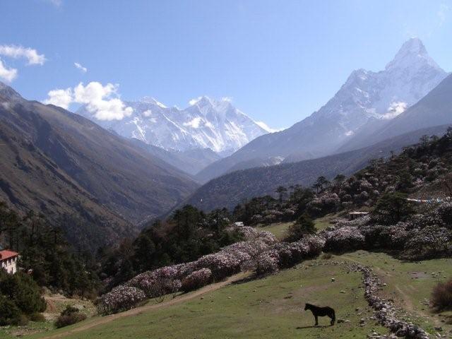
The Annapurna Circuit Trek takes around 16 days and is considered as medium - hard trekking. This trekking route is known as most popular and classical trek in the Annapurna region. Annapurna Circuit TrekkingThis trekking trail is also recommended as one of the twenty best trekking trails all over the world. This trekking trail will take you to the villages with great mountain views, different castes people like Gurungs, Magars, Brahmins, Chhetris, Newars . You will start your trek from Besi Sahar. This trail (Ngadi)can also be seen in The National Geographic but the road has been drstroyed by the landslide. Throughout this trekking trail you will share the way with small caravan who transport supplies to the remote village of this area. There will be a small fields of millet and wheat, small flock of sheeps and goats. Thakalis and tribes controls the trading and pilgrimage trails. You will trek through different small villages like Khudi, Bhulbule, Ngadi, Lampata, Bahundanda, Jagat, Khorte, Dharapani etc.

Itinerary
Day 1 - Besi Sahar to Bahundanda 
Day 2 - Bahundanda to Chamje 
Day 3 - Chamje to Bagarchhap 
Day 4 - Bagarchhap to Chame 
Day 5 - Chame to Pisang 
Day 6 - Pisang to Manang 
Day 7 - Acclimatisation Day in Manang 
Day 8 - Manang to Letdar 
Day 9 - Letdar to Thorung Phedi 
Day 10 - Thorung Phedi to Muktinath 
Day 11 - 16 - Muktinath to Pokhara

Best time
October - November and March - April are the best months for this trek.


Positively reviewed trekking agencies for the Annapurna Circuit Trek are EncountersNepal.com in Kathmandu and Asian Heritage Treks & Expeditions in Kathmandu as well.

trekking features

  • teahouse / lodge trek
  • Length >14 days and < 21 days
  • Maximum Altitude >5000m
  • Difficulty - Hard

Annapurna Circuit Trekking, Nepal details


Javascript is required to view this map.
Average vote based on 1 review.
5
out of 10

Javascript is required to view this map.
Tags:

Location

50° 58' 41.9448" S, 72° 32' 18.978" W

torres del paine trekkingExplore the world renowned trekking routes in Patagonia Chile's most famous national park. Torres del Paine is an internationally acclaimed Chile trekking destination with panoramic scenery, exotic wildlife and diverse ecosystems. the internationally renowned Patagonia trekking destination and park of Torres del Paine lies all in the south of Patagonia, approximately 2500 kms from Santiago. Declared a Biosphere Reserve by UNESCO in 1978, and on the list to be declared a World Heritage site, Torres del Paine is recognized as one of the most breathtaking, unspoiled places on earth. It is believed that the name "Paine" originates from a Tehuelche Indian word meaning "blue". Thus, Torres del Paine means the "Blue Towers". 
The spectacular Paine Massif, with peaks Cuernos (Paine Horns) and Grande, dominates the panoramic landscape of the park. This is the place for Chile Trekking! The park itself is host to numerous ecosystems including, calving glaciers, snow-capped mountains, cascading rivers and waterfalls, lush meadows, mirror-like turquoise alpine lakes, Magellenic forests, arid Pampas. People Trekking in Chile's Torres del Paine Park can expect to see birds like the Andean Condor, Rhea's, Nandu's (American ostrich), Cara Cara's, and Pink Flamingos and mammals like the Guanaco (relative of the domesticated llama), Gray and Culpeo Foxes and possibly Pumas. There are a few trekking options. The famous "W" circuit lets you experience the best of Torres del Paine trekking, all from the comforts our our Patagonia Eco Camp and mountain side inns. Or you can choose for the whole circuit of 11 days including depart from Punta Arenas. You actually hike from day 3 till day 10.

Itinerary: Trekking the Paine Circuit 

Day 1 - Arrive in Punta Arenas on the northern shore of the Strait of Magellan. 
Days 2-3 - Drive to Torres del Paine National Park, followed the next day by a 10-hour roundtrip hike to the incredible granite needles of the Torres del Paine. 
Days 4-6 - Hike through beech forests and open grasslands past beautiful glacier-fed lakes of incredible hue. 
Day 7 - A challenging day: cross Paine Pass (4,000 m) and descend steeply through rough terrain to Lago Grey, skirting the enormous Grey Glacier emanating from the Patagonia Ice Field. 
Day 8 - Hike to the face of the Grey Glacier, then on to Lago Pehoe. Optional half-day hike on the Grey Glacier using crampons. 
Day 9 - Hike into the French Valley, with views of tumbling glaciers and the jagged peaks of the distinctive cuernos (horns), and along the shores of Lago Nordenskjold. 
Day 10 - Take a catamaran across the lake and drive to an hosteria for overnight. 
Day 11 - Drive to Punta Arenas and depart.

trekking features

  • Camping and/or teahouse/lodge trek
  • Length >7 days and < 14 days
  • Maximum Altitude >3000m and <4000m
  • Difficulty - Medium

Torres del Paine Circuit Trek details


Javascript is required to view this map.
Average vote based on 1 review.
5
out of 10

Javascript is required to view this map.
Tags:

Everest Base Camp trekThe superb trek to the Base Camp of Mount Everest is recommended as one of the important sites to be visited before one dies. The trekking trail to Everest is well-known because of the friendly Sherpa people, colorful festivals and the Buddhist monasteries. The region is known as Khumbu and has been bounded in the Sagarmatha National Park, the world heritage site. Sagarmatha is the Nepalese name of Mount Everest, the top of the world. Sherpas, the famous climbers are the dwellers of Khumbu region. Many expedition teams can be observed on this trail during April and May heading higher with an aim to be on the top of the world. 

Suggested itinerary for a 14 days trekking adventure from Lukla

Day 01: Kathmandu to Lukla (2840m) and Phakding (2610m): Fly to Lukla (35 minutes) 
Day 02: Phakding to Namche Bazaar (3446m): Trek. 
Day 03: Rest day at Namche Bazaar: Acclimatization. 
Day 04: Namche Bazaar to Tengboche (3867m): Trek. 
Day 05: Tengboche to Pheriche (4252m): Trek. 
Day 06: Rest day at Pheriche: Acclimatization. 
Day 07: Pheriche to Lobuche (4910m): Trek. 
Day 08: Lobuche to EBC (5360m) to Gorakshep (5160m): Trek. 
Day 09: Gorakshep to Kalapaththar (5545m) to Lobuche: Trek. 
Day 10: Lobuche to Dingboche: Trek. 
Day 11: Dingboche to Tengboche: Trek. 
Day 12: Tengboche to Namche Bazaar: Trek. 
Day 13: Namche Bazaar to Lukla: Trek. 
Day 14: Lukla to Kathmandu: Fly to Kathmandu (35 minutes).Tengboche

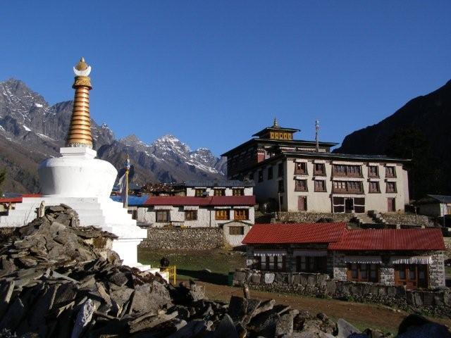
Best time for this trek will be the months of October-December and February-May.

trekking features

  • Camping and/or teahouse/lodge trek
  • Length >7 days and < 14 days
  • Maximum Altitude >5000m
  • Difficulty - Hard

Everest Base Camp trekking details

Average vote based on 2 reviews.
7.5
out of 10

Tags:

Location

44° 6' 39.2436" N, 10° 24' 37.0836" E

The tour begins in Castelnuovo Garfagnana, an ancient village reachable by train or bus, and continues on the first day stretching between small villages and the first real attack of the mountain. Il rifugio rosso is the first destination, since the conquest of Pania della Croce in the next day is nereby this rifugio. And there you should stay as long as possible. The southern slopes pass by the Rifugio Del Freo (the splendor of the place urges night here).
The third stage has two alternatives: the first, most recommended, is that from huts Careggine deviates to the west rising to Sumbra, this is climbing of a certain level, but also very easy) and the second, much more soft, to Screeners for Tassetora Valley.
With the backgrounds of Roccandagia, drum and Horse, the 4th day ends in Val Serenaia the slopes of Pizzo d'Uccello Pisanino and in an atmosphere of absolute tranquility.
Two alternatives for the 5th day, for the less daring there is the dull and quiet paved road access (in some impressive points for overlooking the Valley below Serchio), which at one point finds the path that decreases Gramolazzo, where you must stay overnight.
In the 6th day you move away from the Apuan Alps and begins to taste the Apennine territory. The goal is Mount Argegna, conquered by low wooded hills that form the hinge between the two systems surround the natural boundary, consisting of the Mouth of Carpinelli.
The 7 Day marks the conquest of the Tuscan-Emilian Pradarena Pass to serve as a stopping place, although, officially, once the closing was the underlying Sillano huts in a touristic village (to be checked so that possibilities). Fasten the route of the GEA, the Garfagnana Trekking runs along the Soraggio, the leek and the rest before Romecchio Pass the sweet meadows that surround the beautiful Bargetana Refuge. And we are the 9th day, one that leads to the roof of trekking in Tuscany, M. Prado, above 2000 meters shows us a breathtaking 360 degrees. The stage ends in San Pellegrino in Alpe (a sanctuary), where are a couple of opportunities to stay overnight. The GT definitively closes its run down along a stretch where the trail could be very weak and therefore difficult to detect (therefore important to have a good sense of direction and, of course, a map).

trekking features

  • Camping and/or teahouse/lodge trek
  • Length >7 days and < 14 days
  • Maximum Altitude <2000m
  • Difficulty - Medium

Garfagnana Trekking details

Homepage: www.alpiapuane.com

Javascript is required to view this map.
Average vote based on 1 review.
5
out of 10

Javascript is required to view this map.
Tags:

Location

36° 44' 50.28" N, 5° 23' 23.64" W

From the camp site of "Camping Tajo Rodillo" near Grazalema you can make a nice half-day hike through the Sierra de Grazalema Natural Park to Puerto Presillas. This short hike along fine rock formations will provide some great views of the beautiful surroundings and the village of Grazalema. Click here for more information, a trail description and a detailed map of this short hike.

trekking features

  • Length - day trek/hike
  • Maximum Altitude <2000m
  • Difficulty - Easy

Day hike in Sierra de Grazalema details


Javascript is required to view this map.
Average vote based on 1 review.
5
out of 10

Javascript is required to view this map.
Tags:

Location

43° 19' 9.9876" N, 11° 20' 5.1576" E

Cycling in Tuscany in the Chianti area, in the province of Siena, is one of the loveliest way tot visit this part of Tuscany. Several beautyful villages help you to continue the tough tour of more than 200 kilometers. Whether through the motorway, or crosscountrying with the bikes, or both. See the side for mor detailed information

trekking features

  • Length < 7 days
  • Maximum Altitude <2000m
  • Difficulty - Medium

Hiking in Siena details

Homepage: www.terresienainbici.it/

Javascript is required to view this map.

Javascript is required to view this map.
Tags:

Location

37° 4' 28.236" N, 3° 12' 18.7236" W

Capileira
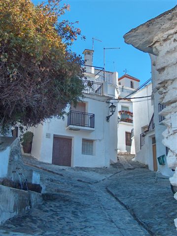
The  (GR240) trek  is a 300 km long, beautiful 15 day trek around the Sierra Nevada mountain range in Andalusia.
Sulayr (mountain of the sun) is the Arabic name for the Sierra Nevada. The Sulayr trek is a new itinerary (2007) divided in 19 parts. The trail is marked with red/white signs and has an average altitude of 1800 metres.
Sendero Sulayr
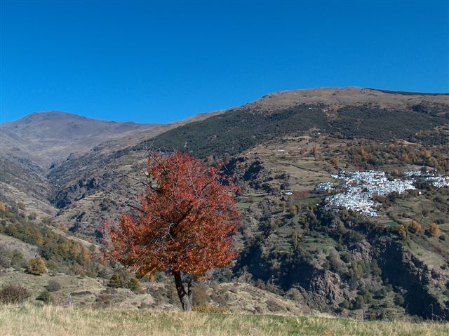
The trail oftens follows the border of the Parque Natural and Parque Nacional de Sierra Nevada and passes several mountain refugios.
Hikers can spend the night in refugios and villages nearby the trail, but this usually means longer walking distances per day. The only two villages "en route" are Capileira and Trevélez in the Alpujarras. Camping is also possible, but you have to inform the authorities of the Parque Natural.

trekking features

  • Camping and/or teahouse/lodge trek
  • Length >14 days and < 21 days
  • Maximum Altitude >2000m and <3000m
  • Difficulty - Medium

Sendero Sulayr (GR240 trek) details


Javascript is required to view this map.

Javascript is required to view this map.
Tags:

Location

45° 44' 59.3304" N, 7° 15' 13.1544" E

From Planaval, in the municipality of Arvier, follow the paved road towards La Clusaz and, after the village, continue to the left, then take the bend after which you come to the start of the trail (at the start of the road). This goes up through a thick wood, initially of broad-leaved trees then conifers, and comes into contact with the ruins of the Bénévy pasture, and ends at the meadows near an aqueduct basin. Go further up to reach a plateau scattered with large rocks. Now continue along the path surrounded by green meadows, then follow the section that runs alongside the stream and crosses over it to the left. The trail then climbs a ridge that leads to another plateau. Go back over the stream towards the right, then continue along a flat section until you come to the remains of Baraques du Fond pasture. Just after the pasture, the trail turns right and goes up to Lake du Fond where, after crossing the brook, it starts to flank a short section of the bank, until it returns to the path on the right that climbs up again amidst the meadows. Go up a number of grassy crags, then take a long right diagonal bend along the hillside, until you come to the final rocky leaps before reaching Col de la Crosatie.<

trekking features

  • teahouse / lodge trek
  • Length - day trek/hike
  • Length < 7 days
  • Maximum Altitude >2000m and <3000m
  • Difficulty - Medium

Planaval - Lac du Fond - Col de la Crosatie details


Javascript is required to view this map.
Average vote based on 1 review.
5
out of 10

Javascript is required to view this map.
Tags:

Location

45° 43' 31.7424" N, 7° 18' 19.2924" E

The mule track goes up into a thick larch and broad-leaf wood until it meets a road from the left that connects Muranche with Falinère. Cross this road and go up to Alpe Promindoz (1850 m), on a panoramic grassy plateau. Further up the larch wood you come to the basin of Cheneil. This was once the only access route to this beautiful basin; now the paved road has been rebuilt that goes right up to Cheneil. From Cheneil continue along the same route past Alpe Champsec (2328 m) and, after a long crossing, you come to Col des Fontaines (2695 m). Cross sparse pastures descending about 60 metres altitude, then continue on level ground until you reach the upper extremity of the Chamois valley. From here, you start climbing again until you come to Col de Nana.

trekking features

  • teahouse / lodge trek
  • Length < 7 days
  • Maximum Altitude >2000m and <3000m
  • Difficulty - Medium

VALTOURNENCHE: Crétaz (1520 mt.) to Col de Nanaz (2773 mt.) details


Javascript is required to view this map.
Average vote based on 1 review.
5
out of 10

Javascript is required to view this map.
Tags:

Location

40° 14' 30.12" N, 9° 29' 30.12" E

Tiscali was an ancient settlement built inside the partly collapsed Tiscali mountain on Sardinia near the village of Dorgali.
Here the inhabitants could hide for the Romans.
Now you can visit the place and see the ruins of a Nuraghe and houses.
It is a difficult hike up to Tiscali, but it is surely worthwhile. You can reach the place via various routes one of them being the following.

Take the main road from Orosei to Tortoli/Arbatax and around one kilometer after the junction towards Cala Gonone you will find a small road (rigth side) leading towards the Su Gorropu canyon.  Follow this road for around 8 kilometers in south east direction. Near Domus de jana Bidua you'll find a place to cross the small river "Flumineddu". At the other side you'll find signs marking the trail up to Tiscali.

You'll find Tiscali at GPS position: N 40.2417 / O 9.4917.

This route will take around 2 to 2,5 hours one way.

trekking features

  • Length - day trek/hike
  • Maximum Altitude <2000m
  • Difficulty - Medium

Day hike to Tiscali details


Javascript is required to view this map.

Javascript is required to view this map.
Tags:

Location

40° 15' 43.0488" N, 9° 37' 29.0712" E

The Selvaggio Blu Trek in Sardinia is one of the most beautiful treks in Italy...... and one of the most wildest and challeging.
The route of this stunning trek/expedition goes from the town of Santa Maria Navarrese (close to Arbatax) to the beach of Cala Luna and involves climbing and abseiling. It follows the coastline the Orosei Gulf, one of the most breathtaking gulfs of the Mediterranean sea.
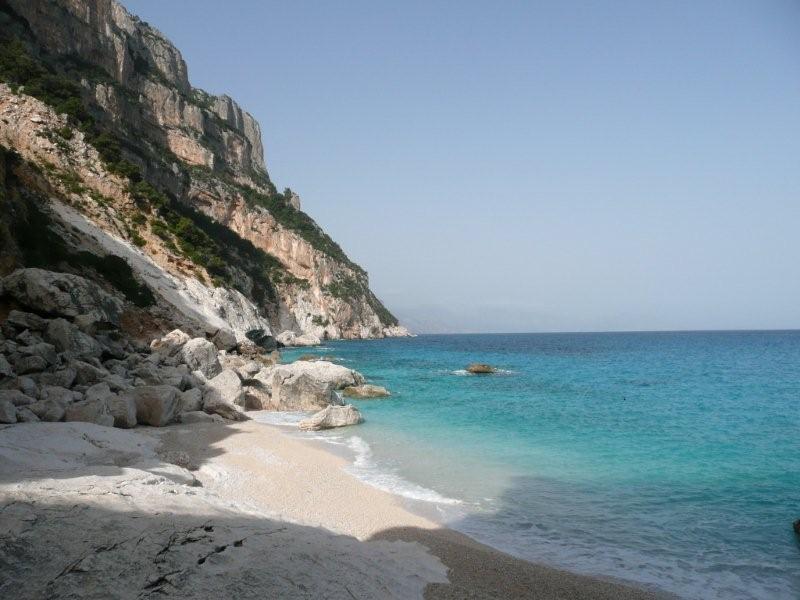
Itinerary: 

Day 1: Santa Maria Navarrese to Pedralonga.
Day 2: Pedralonga to Portu Quau, via Portu Pedrosu.
Day 3: Portu Pedrosu to descend to the beautiful beach of Goloritzè, via Punta Salinas, part of the route goes along the edge of the 200 meter high cliffs over the sea.
Day 4: Cala Goloritzè to the area of Ololbizzi, along the Boladina Canyon
Day 5: Beach near Ololbizzi to Cala Sisine
Day 6: to the beautiful beach at Cala Luna, via the Sedda Eranu pass. From here you can take a boat back to Santa Maria Navarrese or to Cala Gonone.

Best time for this trek: April to June

We recommend you to to this trek/expedition by an organized tour as the second part involves some serious climbing and abseiling.

trekking features

  • Camping Trek
  • Length < 7 days
  • Maximum Altitude <2000m
  • Difficulty - Hard

Selvaggio Blu Trek details


Javascript is required to view this map.

Javascript is required to view this map.
Tags:

Location

42° 48' 33.2892" N, 10° 16' 20.4744" E

From Camping Enfola you reach the main road through the highway Viticcio and take the path n. 49, rising to 750 meters in the scrub oak we arrive at an intersection. Continue on the path number 49 and arrive directly at Forno, a pretty village close to a small sandy beach, while taking no 51 go down first to granitic rocks of the Punta peninsula, then you reach Oven. Oven crossed we get to Scaglieri and following the Biodola, beaches of fine white sand, it continues in the path of the Hermitage hotel to the tennis courts, turn left and then right, reached by a path covered by trees that allows us to admire the gulf Biodola. At the left side a shaded trail that leads us to the beach of Marina and from here you reach the Guardiola, a former military post located on the eastern edge of the Gulf of Procchio.

trekking features

  • Camping Trek
  • Length < 7 days
  • Maximum Altitude <2000m
  • Difficulty - Easy

Viticcio--Procchio Trekking details

Address: Elba
Homepage: www.campingenfola.it/it/trekking-bike.htm

Javascript is required to view this map.

Javascript is required to view this map.
Tags:

Location

47° 59' 50.1864" N, 121° 36' 27.5976" W

The Southern North Cascades Loop is a spectacular 106 kilometer (66 miles)long backpacking trail in the Cascade mountain range in the state of Washington.

Soon more information

trekking features

  • Camping Trek
  • Length < 7 days
  • Difficulty - Medium

Southern North Cascades Loop details

Phone: Southern North Casca

Javascript is required to view this map.

Javascript is required to view this map.
Tags:

Location

37° 0' 46.6308" N, 2° 15' 9.3924" W

The journeys between the points of interest mentioned below can be done both as car journey or hiking tour. The best option might be a mixture. We indicate the main spots of interest, around where you can find interesting walks and places to stay.
Olula de Castro: White town of survival and family subsistence economy. Parish Church of San Sebastián. Archaeological sites, remnants of Rock Art in the Garden of the Moro.
Castro de los Filabres (From Olula De Castro you must go back and get down at Tabernas). Architecture of humble materials: slabs of slate perfectly fit. Remains of Arabic citadel.
Velefique: Pueblo typical white neighborhoods, the remains of the citadel built by exploiting Arabic defense materials hill-Vigía Torre, Church of St. Mary.
Find here a hotel for the night.
Uleila field: white houses covered with tiles, it seems Spanish. Monteagudo step and the Hermitage of the Virgen de la Cabeza. Cueva de la Mora (Neolithic), Parish Church.
Códbar: Pueblo white streets almost parallel, forming a clipped array. Its plains are irrigated with water from five sources manan Cerro de Los marmoreal Calar. The Blacksmith (Alcazaba other Arabic).
Albánchez profile elongated, surrounded by gentle hills covered in a uniform manner, by extensive albaidares. Orange and pear orchards. Roman aqueduct. Ermita de San Roque, s. XII.
Sand: Typical village of Filabres, with its architecture and mastery of the medium. Huertas and nearby quarries. Archaeological sites, El Castillo, El Palomar, Piedras Serradura and the Cueva del Moro.
Chercos: A small street in slope, narrow and irregular. His best monument "Chercos old" and an Arab castle.
Alcudia de Monteagudo: white houses and red roofs guess a new change of scenery. Archaeological sites. Ruins Medal, s. XII-XV (Nasrid). Church of the Rosary Parish, s.VI-VII. Tahal: In the middle of a mountain valley at reaching numerous gullies. Old Berber capital. Castillo Arabic perfectly preserved. Starting point for excursions. Archaeological sites, culture Argar, Neolithic and Bronze Age.
Senese: hidden between hills, look to the south and west. Streets full of character. Remains of Arabic citadel.

trekking features

  • teahouse / lodge trek
  • Length < 7 days
  • Maximum Altitude >2000m and <3000m
  • Difficulty - Medium

Sierra de los filabres details

Homepage: www.venavera.com

Javascript is required to view this map.
Average vote based on 1 review.
5
out of 10

Javascript is required to view this map.
Tags:
Syndicate content
Trekking | trekking-world.com / hiking